13 December 2019

Pacific Crest Trail Topo Maps - A new collection from National Geographic

National Geographic's Trails Illustrated has just released an exciting collection of waterproof topographic map guides covering the entire Pacific Crest Trail at a common scale.


The 11 guides are sold individually and as a set. The full set is available online at these links:

Although my name is Eric Riback, I am not the Eric Ryback who wrote about his adventure as the first through-hiker on the PCT.


27 July 2014

Old Maps Online


Old Maps Online is a great place to find and view... old maps!

10 July 2014

Is Alaska An Island?

It's easy to make fun of this clip from Facebook. After all, everyone should know that Alaska isn't an island, right?


But looking at this Rand McNally wall map below, it's not hard to imagine. Yes, if you really look at the Alaska inset, you'll see it is attached to Canada -- somewhere. The map offers no context or perspective. This is fairly typical of the maps many of us saw in school.


National Geographic did several important things in the depiction of Alaska on their classic U.S. wall map, below. They show the entire state in one image. Insetting the Aleutians, as above, is not desirable. There's an inset map that demonstrates Alaska's size by overlaying it on an outline map of the lower 48. Without that, you will not understand how huge the state is. Finally, there's the inset in the upper right that shows the continent so you see Alaska completely in context.


15 December 2012

Long Before The New Yorker Cover


http://dssmhi1.fas.harvard.edu/emuseumdev/code/emuseum.asp
Daniel K. Wallingford was a visual artist known for his two satirical maps, "A New Yorker's Idea of the United States of America," and "A Bostonian's Idea of the United States of America." Both maps explored the chauvinism of inhabitants of the east coast cities in geographical terms.

http://www.raremaps.com/gallery/detail/18044

Wallingford’s map was first published by The Columbia University Press for the 1936 Times Book Fair.  A second edition was printed for the 1937 Times Book Fair with a note printed on the back by the publisher that it had “appealed so strongly to Fairgoers of 1936 that we have been persuaded to offer it again.”  The map was later redone in color in a larger format on glossy paper, apparently in connection with the 1939 New York World’s Fair.   

13 June 2010

Farewell to the Last Map Store in New York City

American Map Corp. will not be renewing the lease on the venerable Hagstrom Map Store (formerly Hammond Map Store) on 43rd Street in Manhattan. The lease runs until March, but if the landlord finds a new tenant sooner, the store will close.

In addition to the Hagstrom store, New York once had a thriving Rand McNally store, one of the original four along with San Francisco, Chicago and Washington. Long-time manager Edith Snizek was a legend in the business.

The Complete Traveler is now strictly antiquarian, where once they carried current guides and maps. So now the only travel publishing specialist shop in Manhattan will be Idlewild Books, but it is a small store focused on travel literature and experience, with very few maps. Longitude is a web store and does not have a storefont, but does accept walk-in visitors. They carry a good number of maps along with travel books.


Edith Snizek

03 March 2010

It Was Thirty Years Ago Today

In the late 70s, I was working in radio in Portland, Maine, selling ads during the week and DJing on the weekend. It's the only industry I had seriously considered since I was 12.

In 1977 I met a guy socially who had recently started a map publishing company. His name was David DeLorme, and his company has since become a leader in the mapping industry. Then, it was David and a rotating cast of 2 - 4 others who worked for him. I sold him some ads on WBLM, the top rock station in the market.

Months later, he offered me a job as his sales and marketing guy. I dithered on accepting it. I wasn't doing well in radio, but it's all I had thought of for years and I was blind to how perfect for me the job offer was. Eventually I accepted and knew the first day it was a good move. That day was March 3, 1980.

The day I really realized how good I had it was when I made my first road sales trip in April. David sent me up the Moosehead Trail, which is the road from Newport to Greenville, Maine (at the southern end of Moosehead Lake). I was greeted as a returning hero at convenience stores and sport shops. "Hey, it's the map guy! Load me up!" I pulled boxes of maps and atlases out of the car, wrote invoices, and they paid in cash. Cash! In radio, nobody really wanted to buy advertising, and when they did, they really didn't care to pay for it.

Thirty years later, I'm still selling maps. It's been a wonderful career. I've worked for three of the top companies in my field, DeLorme, Mapquest and National Geographic. I've been president of my trade association. I created the first comprehensive web directory of map-related sites. I still enjoy this so much I bought a map company last year, so now I'm a publisher, along with my wife.

Thank you, David.

One of the radio ads I wrote for DeLorme in 1979

22 September 2009

Maps Are Not Buggy Whips

For many of us toiling in the paper map business, it's been tough sledding ever since MapQuest introduced the masses to online maps and directions in the mid-90s, and the advent of affordable in-car navigation systems (also known as GPS or SatNav) and more recently navigation via smart phones.

These technologies have compelling features, and are typically inexpensive or free. It's apparent that many consumers no longer feel the need to own paper maps.

It's important for we map producers to remember that our products are not akin to buggy whips. Buggy whips became useless when horse-drawn carriages were replaced by the automobile. Paper maps and atlases retain the same functionality as they have always enjoyed.

While it's true that digital maps and software can perform some tasks faster and more easily than a paper map, there are drawbacks.

I don't want to suggest that the decline in sales of street and road maps and atlases can necessarily be reversed, but at the least we should be making our case for the usefulness of our product in marketing, product covers and displays in a way that might resonate with the public.

Eventually, those who have moved totally to digital solutions will experience equipment failure, difficulty finding a good re-route around traffic, a desire to know where they are in some kind of context, the ability to plan future trips with rich information.

Let's be there when they begin to again appreciate the value of paper maps.

12 September 2009

01 September 2009

Celebrating Hand-Drawn Maps

Visit the Hand-Drawn Map Association for some creative hand-made cartography!

28 August 2007

Maps Are Our Future


Thanks to Curtis Carroll of Benchmark Maps

Update:

Upton was more composed on the Today show. “I would love to re-answer that question,” she told Ann Curry. “Well, personally, my friends and I, we know exactly where the United States is on our map. I don’t know anyone else who doesn’t. If the statistics are correct, I believe there should be more emphasis on geography in our education so people will learn how to read maps better.”

More here.

24 February 2007

Map Vending Machines


After the oil companies stopped distributing free road maps in the 1970s, a new business was born. You could start your own business by buying map vending machines and placing them in gas stations and other locations. At that time, the gas stations didn't want to deal with buying and stocking maps, but they wanted to have them available (just as some convenience stores don't sell newspapers, but have machines outside).

After a decade the machines started disappearing as the major map companies began to control their own distribution, and found they could sell a wider range of products thatn just road maps in many of these locations.

The machine pictured above is in the car wash I go to, and it's the first one I've seen in many years. The maps in it are priced at $2.00, so you know they've been there a while, since most street and road maps are now at least $3.95. I think the machines were never updated once map prices rose and can only accept eight quarters.

One of the country's largest map publishers was born of the vending machine business. Two men in Lansing, Michigan, Bob Bond and Bert Green attended a meeting where the vending machine company was making the "own your own business" pitch. They both got into it and at some point decided to be partners. The company they formed is Universal Map Enterprises, now with offices in Michigan and Florida. At first, they were content to distribute maps of other publishers such as Gousha (now defunct). But they couldn't find a good map of Lansing, so they had one made. From that point they became a publisher as well as a distributor and now mosy of what they sell carries the Universal brand.

Here is an innovative use of a map vending machine. It has art created to fit and sell for $2.

09 September 2006

Raven Maps

Simply put, Raven publishes beautiful wall maps. Most using hypsometric tints. This is a system of assigning different color values to elevation ranges. It's an effective way to display elevation, but Raven uses this method to great decorative advantage. Map titles include the world, USA, and individual states.

Cartifact Gallery of Jan Smits


A great collection of products, advertisements, etc. that use map images, and map-image products.

We in the industry call map-image products "map crap" but that's often unfair. Some of them are really nice!

07 September 2006

Road Map Collectors Association (RMCA)


Road maps are a special interest area that crosses two others: map collecting and automobilia. The RMCA web site offers lots of information on road maps, links to buyers and sellers, swap events and much more. The group hosts an active listserv and publishes a periodical newsletter for members.

06 September 2006

Stanford's

Want to see the biggest and best map store in the world?

Visit London, and steps from Covent Garden you'll find Stanford's.

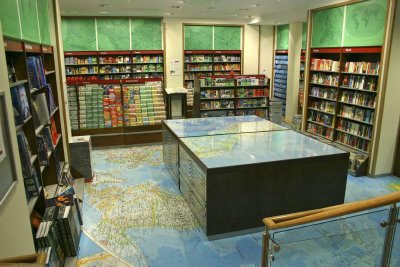
They recently celebrated their 150th anniversary with a total refit of the main store (they have locations Bristol and Manchester as well).

One of the unique features is that the floor tiles comprise enlarged images of maps.


At Stanford's you'll find the largest selection and most knowledgeable staff anywhere.